

JUNE 11, 2014
Three areas temporarily closed on the Sitgreaves National Forest as of today
SPRINGERVILLE – In order to protect public health and safety due to increased fire danger, temporary closures of three areas on the Sitgreaves National Forest were implemented at 8 a.m. today. The public is prohibited from going into or being upon the closed areas on National Forest System (NFS) lands. Exempted are law enforcement officers or firefighters on official duty, residents accessing their private property, and persons engaged in business with a Forest Service permit.
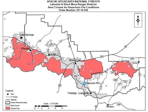
The largest closure area is on the Lakeside and Black Mesa Ranger Districts near the communities of Show Low, Pinedale, Clay Springs, and Linden. Most of this area was the site of the 2002 Rodeo/Chediski wildfire. The effects of the drought on grass and rotting trees have created conditions favorable to a fast moving wildfire in this wildland-urban interface. The adjacent Show Low South area also has conditions that place it at higher risk of wildfire and is being closed to protect communities that potentially would be in the path of wildfires in the area.
The Timber Mesa/Porter Mountain area to the east of Show Low is being closed to protect a communications site that serves most federal, state, county and local law enforcement and private companies. Public safety is dependent upon this communications site. This area has several miles of heavily-used trails through forest with a substantial fuel load placing it at higher risk of wildfire.
Although a sizeable area south of Vernon has been treated for hazardous fuels conditions, a wildfire in the area to the southwest potentially would put the community of Vernon at risk. Therefore, the forest area southwest of Vernon is being closed.
Fuel treatments, including mechanical thinning and broadcast burns, are planned for all of these areas in the future in order to reduce the need for future closures. At this time, other areas are not being considered for closure because they have received fuel treatments, are not as dry, or are not in locations where downwind communities are at risk.
The closure areas (see map below) are defined as follows:
• Rodeo/Chediski/Show Low South Closure Area: This area is the west side of the Lakeside Ranger District and a small portion of the Black Mesa Ranger District south of Hwy 260.
• Western boundary is NFS Road 139 starting at the junction of Hwy 260 and NFS Road 139, traveling south to NFS Road 141 and NFS Road 139 junction, then traveling west to NFS Road 300 and NFS Road 141 junction, and then due west to Fort Apache Indian Reservation.
• Southern boundary is the boundary of the Fort Apache Indian Reservation from the junction of NFS Road 300 and 141, junction west to Reservation Boundary, then traveling east along Reservation Boundary to private land boundary 2¾ miles east of Hwy 60.
• Eastern boundary is private/NFS land boundary on western edge of Wagon Wheel area.
• Northern boundary is alongside the southern edge of State Highway 260.
Timber Mesa Closure Area:
• Western boundary is alongside the eastern edge of Penrod Road starting at the intersection of Porter Mountain Road and Penrod Road traveling northwesterly along Penrod Road to the intersection of Highway 60
• Northern boundary is alongside the southern edge of U.S. Highway 60 starting at the intersection of Penrod Road and Hwy 60 traveling easterly to old Apache Railway right of way at Bell Siding.
• Eastern boundary is the old Apache Railway right of way located in the middle of Woolhouse Quiet Area, starting at the intersection of Hwy 60 and traveling southeasterly to the intersection of Porter Mountain Road.
• Southern boundary is alongside the northern edge of County Road 45 (Porter Mountain Road) traveling westerly on Porter Mountain Road to the intersection of Penrod Road.
• Excluded areas: Porter Mountain cinder pit and access road, Flume Mountain cinder pit, private landowner access and private land.
Southwest Vernon Closure Boundary:
• Northern boundary starting at junction of NFS Road 283 and Apache County Road 3144 proceeding easterly along its southern shoulder to where the road leaves the Forest, then proceeding easterly along forest northern boundary until the intersection of Apache County Road 3140.
• Eastern boundary proceeding southerly along the western shoulder of Apache County Rd 3140 to the junction of NFS Road 3.
• Southern boundary proceeding westerly along the northern shoulder of NFS Road 3 to the junction of NFS Road 283.
• Western boundary proceeding northerly along the eastern shoulder of NFS Road 283 to the junction of NFS Road 283 and Apache County Road 3144.
The Apache-Sitgreaves National Forests are in Stage II fire restrictions. Campfires, charcoal and other fires are prohibited everywhere. Propane devices that can be turned on and off are allowed, but must be in an area cleared of flammable materials. Smoking is prohibited except within enclosed vehicles or buildings. Travel off designated roads and trails is prohibited. Operating any internal combustion engine is prohibited from 10 a.m. to 9 p.m. Welding or other torches with open flames are prohibited. Fireworks and explosives are always prohibited on U.S. Forest Service lands. For more information, visit www.fs.usda.gov/asnf.
Follow the Apache-Sitgreaves National Forests on Twitter (@A_SNFs) for instant updates on closures, fire restrictions, and fire information.
